5 NEW GEOSPATIAL BIG DATA EXPLORATION TIME HACKS IN ARLAS v16
The ARLAS evolution continues. More functions that keep with our promise to get you exploring your geo-big data quickly and without limitations.
TIME HACK NUMBER 1 The layers are now available in new styles; dashed/dotted highlights. Dotted lines are useful for highlighting gaps in the trajectory. This function is built-in ARLAS v16, using ARLAS Proc ML, our in-house Machine Learning processor - side note, watch out for ARLAS Proc ML special news this summer. The solid lines show when the track consists of regular position emissions. So you can quickly visually identify and sort your data by the type of duration. The other new style within the layer’s functions is the ability to filter one layer at a time and only explore its data with a specific layer style. In the example above, we apply the dotted style by filtering the tracks that have gaps > 1 hours and the solide style by filtering the gaps < 1 hour

TIME HACK NUMBER 2 We also have a new histogram exploration function. While the histogram in version 15 already provides you with a lot of information, the ability to zoom in further on specific parts of the histogram and study them in detail is invaluable. Especially if the visualised result instantly applies to all selected data.

TIME HACK NUMBER 3 You will probably enjoy how ARLAS 16 saves you with hacks that not only free up your time but also limit errors from trials. For example, if you already created a layer and may need to reuse it with a different dataset or slightly different style, you go ahead and duplicate it.


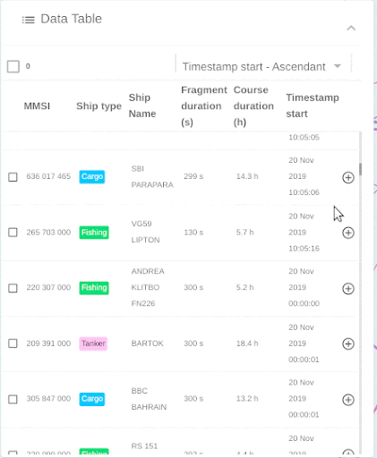
TIME HACK NUMBER 4 Oftentimes, voluminous information is stored in tabular form of rows and columns creating a data table. How your data table is designed and styled supports you to organise your data for; emphasis, clarity,hierarchy, alignment, contrast and context. We offer new functionalities to improve your data table within ARLAS. In ARLAS v16, you can for example, assign them colours with a direct result on your visualised data as shown below. This is besides other data table settings that already exist in ARLAS.

TIME HACK NUMBER 5 ARLAS v16 also supports quick exploration of your data by directly linking your view on the map to your data table. You make the selection row on the dataset, and see the corresponding view on the map. So, you can have multiple rows highlighted or only focus on one row for analysis.

BONUS HACKS
Base-maps Sticking with style, you get to choose the base-map onto which your data is displayed. This you can try right below your visualised data to make the choice based on what makes your data stand out. An important feature of data storytelling.

Tooltips Because we want geo-big data exploration to be accessible to all including people with non-technical skills, ARLAS enhanced tooltips that explain the metrics on the diverse widgets to keep everyone reading the data on the same page, and with limited dependency on others.

Synchronising colours We understand that harmony in data visualisation makes it easier to quickly link up information. Using colours to denote the same information across different panels helps you simplify presentation to others, reinforcing visual communication from the data. That is available on ARLAS as displayed below.

Unit
Sometimes the question is simply, how many? How many assets, vessels or whatever unit you want to highlight after a global count? Taking ship as an example here, ARLAS quickly provides the number from the visualised data as shown below on the top left bar.
In ARLAS builder, it is set under the look and feel section.

Organise WidgetsWithin the ARLAS builder, you have an opportunity to re-order your widgets and display them as you wish. This allows you to showcase your data based on your preference or for clarity for your final presentation.
Rename DashboardsOnce you have created your dashboards, you may want to rename them to match indicators that you are exploring or identified. This means that you can start with a working title for the dashboard and later rename it appropriately. It is also a useful function when you just need to duplicate the dashboard to reuse the same dataset but for a different type of exploration.
Get Started
ARLAS version 19 documentation is already available here on our website and also captured on Github. You can also access our live demos where you can see the results of all the possibilities in place. Once you are ready to start, consult our tutorials and let us know how you are using ARLAS.