SIMPLIFIED GEOSPATIAL DATA EXPLORATION
Navigating the vast landscape of geospatial analysis just got a whole lot easier with the latest update of ARLAS. GIS experts, data scientists, and decision-makers have a smooth time interacting with geolocated datasets and images.
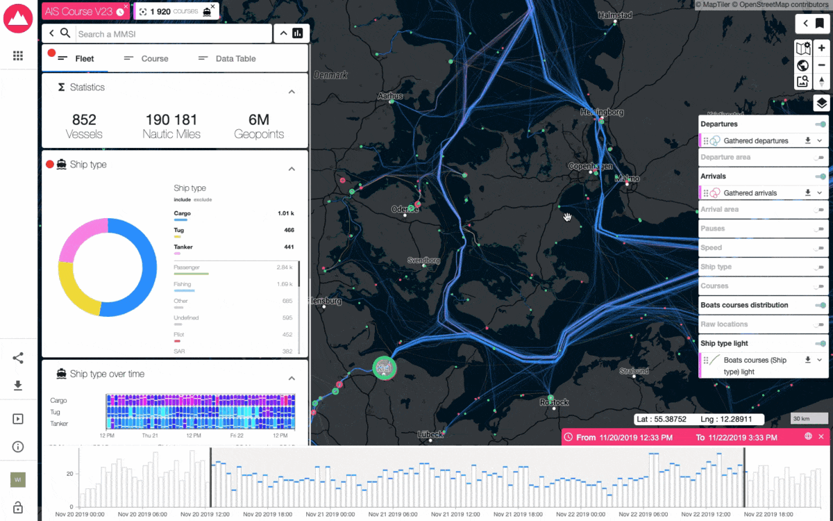
Imagine diving into a vast sea of data, like population density, weather patterns, or sea vessels, and being able to zero in on the most relevant information with ease. Thanks to ARLAS version 23, with a suite of new features, you can swiftly identify and highlight the data that matters, making analysis more efficient and effective.
With a cleaner, more focused visual representation of data, interpretation becomes smoother and decision-making faster.
EXPORT VISIBLE LAYER AS GEOJSON OR CSV
Working with spatial data often involves using a variety of tools. ARLAS version 23 bridges this gap with its ability to export visible map layers as Geojson or CSV.
This means a public health officer tracking a disease outbreak can export the data layer showing disease hotspots and delve deeper into analysis with other tools like QGIS.
It's a powerful way to unpack geographic trends and make informed strategies.
DISPLAY A LABEL ALONG A LINE
Enhancing data visualisation is at the heart of ARLAS version 23. With its Display a Label Along a Line feature, users can overlay text on line string geometries.
Imagine a logistics manager monitoring shipping routes and being able to see the names of vessels directly on the map.
It's immediate visual insight at its best, aiding in quick and informed decision-making.

POWERBAR FRESH STYLE
The user experience is front and centre in ARLAS version 23. With the fresh new style of the powerbar, navigating and interpreting data becomes more intuitive and enjoyable.

COMING SOON… ARLAS VERSION 24
But we don’t stop there. ARLAS version 24 will offer users even more tools for geodata analysis and visualisation. From new shortcuts for quick filters to an even more flexible self-hosted basemap, the general redesign of ARLAS makes it a truly comprehensive tool for geospatial analysis.
Whether it's providing extra context about a point of interest or comparing data from different collections, ARLAS's main goal is to eliminate all technical barriers and promote easy access to insights from geospatial big data.
Get Started
ARLAS version 23 is more than just a tool; it's a gateway to exploring, analysing, and visualising geolocated images and data. Designed with GIS experts, data scientists, and decision-makers in mind, it's all about making more informed decisions, faster.
ARLAS version 22 documentation is already available here on our website and has also been captured on Github. You can also access our live demos where you can see the results of all the possibilities in place. Once you are ready to start, consult our tutorials and let us know how you are using ARLAS.
Our team is also available to discuss how the ARLAS framework can quickly help you build geoanalytics solutions for your data. Contact us.